![Severe Weather a Possibility Today [UPDATE: 1:00 p.m.]](http://townsquare.media/site/187/files/2011/11/weather.jpg?w=980&q=75)
Severe Weather a Possibility Today [UPDATE: 1:00 p.m.]
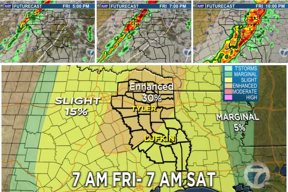
East Texas is receiving some much needed rainfall, but throughout the day there is also a possibility of strong to severe storms. We will keep you posted both on-air and online! Be sure to"like" us on Facebook to receive updates. You can also stay ahead of the storms by checking our interactive radar on the weather page!
UPDATE 1:00 p.m.
All tornado watches have been cancelled.
UPDATE 12:20 p.m.
Oncor reports about 15 hundred customers without power in the East Texas area, mainly central East Texas, Jacksonville, Tyler and Lindale
UPDATE 11:40 a.m.
Swepco reports power outages in Rusk and Panola Counties, Rusk has 271 Swepco customers without power and Panola has 683 customers without electricity.
UPDATE 10:55 a.m.
The National Weather Service has issued a Tornado Warning for South Central Panola County until 11:45 a.m. The storm is located 14 miles Southwest of Carthage - moving Northeast at 45MPH.
UPDATE 10:30 a.m.
The National Weather Service has issued a Severe Thunderstorm Warning in effect until 11:30 a.m for Southern Gregg County, Southern Harrison County and Eastern Rusk County.
UPDATE 10:15 a.m.
The Tyler police departments is reporting high water at the intersections of Douglas and Noble, Erwin just west of Palace and Calloway near Lazy Creek. DPS is reporting multiple non-serious accidents on I-20.
Emergency officials in Anderson County are reporting trees and power lines down on CR 444 and FM 315 in Anderson County. At this time no injuries are reported.
Cherokee County Dispatch reports a tree down at county road 1911 at county road 1247 near Wells
UPDATE 10 a.m.
The National Weather Service has issued a flood advisory for Smith and Cherokee Counties until 11 a.m.
The warm front is currently located along the Smith/Cherokee County line. Areas to the south of the warm front have the greatest chance of seeing tornadoes. However, the front will continue to move to the north throughout the day.
The Department of Public Safety in Tyler reports they are working several traffic accidents on I-20 in Smith and Van Zandt Counties. None appear to be major, but DPS reminds motorist to slow down during the wet road conditions.
UPDATE 9:50 a.m.
The National Weather Service has issued a Severe Thunderstorm Warning in effect until 10:30 a.m. for Cherokee and Rusk Counties. Winds in excess of 60 mph are expected with this storm. Storm currently located 19 miles south of Rusk moving to the Northeast at 55 mph.
UPDATE 9 a.m.
Severe storm near Palestine with 50MPH winds. Should be in Southern Smith County within the hour.
The National Weather Service has issued a Significant Weather Advisory in effect until 9:45 a.m. for Smith, Upshur, Wood and Cherokee Counties. Pea size hail and winds in excess of 40 to 50MPH are expected with these storms.
UPDATE 8 a.m.
A severe thunderstorm warning has been issued until 9:15 a.m. for Anderson County.
UPDATE 7 a.m.
The National Weather Service has issued at tornado watch in effect until 11 a.m. for Anderson and Henderson Counties and until 3 p.m. for Cherokee and Rusk Counties.
UPDATE 4 a.m.
The main threat will be strong straight-line winds, but there will also be the possibility of tornadoes. The tornado threat area will depend on the location of the warm front, which is expected to be along the I-20 corridor. If that is the case, the storms near and south of that boundary will pose the greatest threat.
More From KKTX FM


![Scary Footage Shows Motorists Fleeing Grapevine, TX Tornado [VIDEO]](http://townsquare.media/site/156/files/2022/12/attachment-grapevine-tornado.jpg?w=980&q=75)